A History of the Bob Graham Round
Although it is known as the “Bob Graham”, his was not the first attempt at a long day out in the fells. In the years leading up to Bob Graham’s 1932 round there had been many other long distance circuits over the fells. The following is a short account of the years leading up to the first traverse of the round attempted by so many today.
The recorded tale begins in around 1864 with a clergyman, Reverend J. M. Elliot of Cambridge who, based at Wasdale Head, traversed the high fells surrounding that valley in 8.5 hours.
Six years later Thomas Watson from Darlington, along with a “guide” from Borrowdale by the name of Wilson set off from Keswick with the aim of climbing the 3000ft peaks of Lakeland (Scafell, Scafell Pike, Helvellyn and Skiddaw) within 24 hours. This “round” took 20 hours for a distance of 48 miles and 10,000 feet of ascent and descent.
The following set of rounds, proto-rounds and attempts comes from Baddeley’s Lake District guidebook.[1] It has been assumed that the parties did not visit other peaks or tops unless explicitly mentioned.
1883 Charles and Lawrence Pilkington and Matthew Barnes Lodore - Great Gable - Scafell Pikes - Great End - Bowfell - Fairfield - Helvellyn (via Dollywaggon Pike) - Blencathra - Skiddaw - Lodore. 24hrs 25 mins
Getting from Bowfell to Fairfield without explicitly including intervening tops such as the Langdale Pikes or High Raise seems odd. However the description of the 1902 round of Johnson and Strong (see below) indicates that the preferred way at the time was to ascend/descend Bowfell via The Band and Stool End Farm follow the road down Langdale then go via Red Bank to Grasmere thus avoiding the tops altogether.
1893 Robinson and Gibbs Keswick - Great Gable - Scafell Pikes - Great End - Bowfell - Langdale Combe Head - Wythburn - Helvellyn - Blencathra - Skiddaw (abandoned on Skiddaw). 23hrs 25
This round is interesting in that the descent into Langdale is now avoided, hence the references to Langdale Combe and Wythburn. However getting to Wythburn from there without traversing at least one top (my guess would be High Raise) and not mentioning it is somewhat strange.
This round was also unusual in that it was attempted towards the end of October. They carried alpenstocks (very long handled ice-axes) and “found plenty of use for them in the snow and ice on Scafell, while Gibbs had to be let down the slippery ledges of Broad Stand by means of the rucksack, kicking the ice off the holds. ” (Griffin 1963 p.87)
1895 Dawson, Poole and Palmer Elterwater - Bowfell - Scafell Pikes - Skiddaw - Helvellyn - Grasmere - Elterwater (via Rydal and Ambleside). 19hrs 18
Palmer who apparently was the only one of the three who knew the route between the central fells and Helvellyn (Griffin 1963 p.87) retired with an injured knee on Scafell.
1898 Broadrick Windermere - Bowfell - Great End - Scafell Pikes - Scafell - Great Gable - Skiddaw - Helvellyn - Windermere. 20hrs 30 (The 12 miles from Windermere to Stool End in Langdale were done on a bike)
The account of this round mentions ascending Bowfell via Hell Gill which lies just to the south of The Band rather than The Band itself.
1899 Westmorland, Strong, Johnson and Beaty Seathwaite - Great Gable - Pillar - Scafell - Scafell Pike - Bowfell - Wythburn (via Langdale Combe and High Raise) - Helvellyn - Blencathra - Skiddaw - Keswick. 19hrs 25
The first round (though note the different start and finish) to include any of the fells to the west of Great Gable. The omission of Kirkfell suggests that the trod used by the Wasdale Fell Race around the northern flank of Kirkfell was taken. Also note that High Raise is now explicitly mentioned.
1899 Westmorland and Beaty same fells from Threlkeld to Threlkeld in 23hrs 30
These two must have enjoyed the earlier attempt and so actually had another go at a complete round only a month or so after their previous effort.
1901 Broadrick Rosthwaite - Great Gable - Pillar - Scafell - Scafell Pike - Bowfell - Fairfield - Helvellyn - Blencathra - Skiddaw -Rosthwaite. 23hrs 30
1902 Johnson, Strong Threlkeld - Helvellyn - Fairfield - Bowfell - Great End - Scafell Pike - Scafell - Pillar - Great Gable - Skiddaw - Blencathra - Threlkeld. 22hrs 7
About 1902, Mr. S. B. Johnston of Carlisle accompanied by M. Strong set off from Threlkeld at 5a.m. By 7:20 they were on the summit of Helvellyn, by 8:19 Fairfield. They passed through the village of Grasmere at 9:12 thence over Red Bank to Langdale, arriving at Stool End Farm at 10:15. Mr. Westmorland joined them as guide. The summit of Bowfell was reached at 12 noon. Wasdale Head at 3:20 having traversed the Scafell range. Then, via Door Head to Pillar at 4:33. Seathwaite via Gable at 7.25. They stayed 45 minutes at Seathwaite resting and refreshing themselves. With Mr. Beaty now leading they reached Keswick in under 2 hours, the summit of Skiddow at midnight. They marked out a course by the stars to reach Blencathra at 2:10 The descent down Halls ridge to the Lead Mines took some 45 minutes, Threlkeld, the starting point, was reached at 3:07, the round trip taking 22 hours 7 minutes.[II]
The comment “Then, via Door Head to Pillar” indicates that Red Pike was traversed but maybe not visited. Door Head is the col at the northern end of Yewbarrow and for many years had a well known scree run down to the valley floor which would be useful on an anti-clockwise round using this route.
1904 Wakefield Keswick - Great Gable - Kirkfell - Pillar - Scafell - Scafell Pike - Bowfell - Fairfield - Helvellyn - Blencathra - Skiddaw - Keswick. 19hrs 53
The first appearance of the redoubtable Dr Wakefield of Keswick.
With allowances for possible minor variations, these four rounds are the same. It is believed, by dint of omission, that the northern Helvellyn tops were not traversed. In which case the most likely descent would be to the public house at Thirlspot and then by road through St John’s Vale to Threlkeld.
The roads in the district weren’t paved at this time. In fact the modern asphalt surface wasn’t invented until 1901 and widespread asphalt surfacing in England didn’t really begin until around 1910 so the surface of many country roads was probably closer to that of modern forest fireroads or rougher - hardly any better than keeping to the tops. The time of the Johnston and Strong team in getting from Threlkeld to Helvellyn in 2hrs 20 minutes is not too dissimilar to that of a modern round going over the tops.
It is possible that certain areas of the fells or fell approaches were simply “Off-limits” with land owners or estates preventing access hence the avoidance of lines of fells such as the northern Helvellyn section.
1905 Wakefield Keswick- Robinson - Hindscarth - Dale Head - Brandreth - Green Gable - Great Gable - Kirkfell - Pillar - Steeple - Red Pike - Yewbarrow - Scafell - Scafell Pike - Great End - Hanging Knott - Bowfell - Fairfield - Dollywaggon Pike - Helvellyn - Blencathra - Skiddaw - Keswick. 22hrs 7
This was the first round to include the Dale Head group. Also note that Kirkfell and the remainder of the tops around the head of Wasdale are now included. In fact, with the exception of the section between Bowfell and Fairfield as previously noted and the omission of the northern Helvellyn section, this is a prototype “Bob Graham Round”
Next was Eustace Thomas who, in 1920 at the age of 53 and coached by Dr Wakefield, covered the same route in 21 hours 25 minutes.
1920 29 May Eustace Thomas Virtually as above but in 21hrs 25
Thomas appears to be a remarkably fit and in common with many of the early protagonists may be regarded as an outdoor polymath. He was the first Briton to climb all the 4000m peaks in the Alps and he also was responsible for the route now taken by the High Peak Marathon as well as doing the first traverse of the Welsh 3000ft peaks. Not satisfied with repeating Wakefield’s route, two years later he improved on it:
1922 Eustace Thomas Keswick - Robinson - Hindscarth - Dale Head - Brandreth - Green Gable - Great Gable - Kirkfell - Pillar - Steeple - Red Pike - Yewbarrow - Scafell - Scafell Pike - Bowfell - Fairfield - Helvellyn - White Side - Raise - Stybarrow Dodd - Great Dodd - Clough Head - Blencathra - Great Calva - Skiddaw - Keswick - Grisedale Pike - Grasmoor - Wandope - Eel Crag - Sail - Causey Pike - Newlands. 28hrs 5
Note the inclusion of Great Calva. This was also the first round to include (at least explicitly) the tops on the ridge to the north of Helvellyn, though no Watson’s Dodd. No start or finish point is given in Baddeley, in fact Thomas started in Keswick and after completing the round went on to add the Grasmoor group.
Despite this, the list of peaks (omitting the Grasmoor group) looks remarkably similar to a modern round, add in those tops that would be traversed or passed close by: Grey Knotts; Broad Crag; Ill Crag; Great End; Esk Pike; Dollywaggon Pike; Nethermost Pike; Helvellyn Lower Man, Watson’s Dodd and the only tops missing are those nine on the modern round between Bowfell and Fairfield.
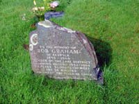
Bob Graham's grave at Stonethwaite. (Jonathan Steele)
There were several attempts to better Thomas’s time, but it was not until 1931 and the arrival of one Robert Graham, a hotelier from Keswick that it looked like being beaten. Graham’s first attempt ended in failure due to a navigational error and he became determined to succeed the following year. The delay of a year meant adding another peak to the list of tops: one for each of his 42 years. Bob Graham took 23 hours and 39 minutes to complete his round in a clockwise direction. The claim at the time was that the round was a distance of 130 miles and 32000ft of ascent. Clearly, the journalists of the time were as adept at hyperbole as they are today. This record would stand for another 28 years.
1932 Bob Graham “created what is probably a world’s walking record” Keswick - Skiddaw - Great Calva[1] - Blencathra - Wanthwaite Pike (Clough Head)[2] - Helvellyn[3] - Dollywaggon Pike - Fairfield - Seat Sandal - Steel Fell - Calf Crag - High White Stones[4] - High Raise - Sergeant Man - Harrison Stickle - Pike O’ Stickle - Rossett Pike - Hanging Knotts - Bowfell - Esk Pike - Great End - Scafell Pike - Scafell - Yewbarrow - Red Pike - Steeple - Pillar[5] - Kirkfell - Great Gable - Green Gable - Brandreth - Dale Head - Hindscarth - Robinson - High Snab - Keswick. 23hrs 39 [6]
Some irregularities -
- It is likely that Graham knew the details of Thomas’s round so there is a reasonable chance that Great Calva was part of his original plans. However, as noted in earlier, Phil Davidson (one of his pacers) stated that this was the extra peak added to tally with Graham’s age.
- I think that Wanthwaite Pike is the same as Clough Head - there is no summit of that name around Threlkeld. Wanthwaite Crags lie just to the west of the summit. The 1867 map of the area does not show any summit by this name
- Great Dodd - Watson’s Dodd - Stybarrow Dodd - Raise - Whiteside are not listed but it is known from other sources [citation needed] that he traversed these.
- High White Stones is “a slightly marked elevation a little south of Greenup Edge” this could be the prominence at 282101) but is marked on modern maps as the summit area of High Raise so do not understand why both are listed. One consideration is that fells often have two names - one is the name of the pasture used by farmers and shepherds, the other is for the summit itself.
- Looking Stead, on the ridge down from Pillar to Black Sail Pass, is given as one of the original 42 but is missing from this list.
- Rogerson (1979) gives the current 42 rather than the original set. Also High White Stones is named rather than High Raise.
Thus this list only gives 34 tops (39 if the northern Helvellyn ones are added) for Bob Graham’s round, not the considered 42. He would have to have passed over Helvellyn Lower Man and would have passed over or close to Nethermost Pike, Thunacar Knott and Grey Knotts. These would take the total to 43.
Griffin (p.87)notes that “On Buttermere Red Pike it started to rain and there was mist on Robinson and Dale Head ... but when they reached Newlands Hause they knew it was downhill all the way home and that they could not fail.” I think that there is confusion here between the Red Pikes of Buttermere and Wasdale - the latter is most certainly traversed whereas the Buttermere fell is not on any usual round being on an outlying ridge. Also it is mentioned that they took just 39 minutes for the seven miles from Newlands Hause back to Keswick - hardly likely at that stage in a round. Both Baddeley and Smith note that High Snab, not really a summit in any sense of the word, was traversed. If this was the case, and it makes more sense, then Graham would not have visited Newlands Hause. It is possible that Griffin confused Graham’s round with that of Alan Heaton who did go via that route.
Graham used four pacers in a relay, some of the pacers pacing more than one section. Although the round mentioned in these pages is usually referred to as the “Bob Graham Round” it does not take in the same tops as the original. Graham’s round did not include Helvellyn Lower Man, Ill Crag or Broad Crag despite his route passing over the first and close to the other two. In their place were Hanging Knotts, Looking Stead and High Snab (Smith W. 1985 p.87). The first of these is on Bowfell, the second on Pillar and the last on the North Ridge of Robinson. In fact Hanging Knotts and Looking Stead are often included in attempts at a 50 at 50 or higher round.
There were attempts to better this round almost immediately but weather and luck played their part. It was not until 1960 that the record was finally beaten by Alan Heaton of Clayton-le-Moor Harriers, who ran an anti-clockwise circuit in a time of 22 hours 18 minutes.
The record stands at an incredible posted by Billy Bland in 1982. His pacers reported that the final road section (again on a clockwise round) was taken at 6 minute mile pace! It may be another 28 years before this is broken!
So how do these early rounds compare? Tracing the approximate routes using modern mapping software gives the following table.
| Year | Name | Distance(Km) | Ascent (metres) |
|---|---|---|---|
| 1893 | Charles and Lawrence Pilkington and Matthew Barnes | 81 | 5367 |
| 1893 | Robinson and Gibbs | ||
| 1895 | Dawson, Poole and Palmer | ||
| 1898 | Broadrick | ||
| 1899 | Westmorland, Strong, Johnson and Beaty | ||
| 1899 | Westmorland and Beaty | ||
| 1901 | Broadrick | ||
| 1902 | Johnson, Strong | ||
| 1904 | Dr Wakefield | ||
| 1905 | Dr Wakefield | 94.2 | 7115 |
| 1920 | Eustace Thomas | 94.2 | 7115 |
| 1922 | Eustace Thomas | 95.7 | 7635 |
| 1932 | Bob Graham | 105.6 | 8140 |
Record times
The image below shows where the various record holders would be if they had all set off at the same time as the current record. For the sake of convenience all are assumed to be on a clockwise round, even though some of them actually did their run on an anti-clockwise circuit. Note that Mark Hartell did not hold the record but his is the second fastest time and is included to demonstrate just how far ahead Billy Bland’s time really is.
The time that Bob Graham himself achieved is the standard schedule time of 23:30, though it is often referred to as a 23hr schedule.
Click on the play button below to run the sequence. The “Stop” and “Reset” buttons have the expected behaviour. The sequence takes approximately 12 seconds to run completely.
The actual times are given below.
| Date | Name | Direction | Time |
|---|---|---|---|
| 1932 June 13 | Bob Graham | Clockwise | 23:39 |
| 1960 June 25 | Alan Heaton | Anti-clockwise | 22:18 |
| 1971 July 10 | Pete Walkington | Anti-clockwise | 20:43 |
| 1973 August 17/18 | Bill Smith & Boyd Millen | Anti-clockwise | 20:38 |
| 1976 June 19/20 | John North | Anti-clockwise | 19:48 |
| 1976 August 14 | Billy Bland | Clockwise | 18:50 |
| 1977 August 13 | Mike Nicholson | Clockwise | 17:45 |
| 1982 June 19 | Billy Bland | Clockwise | 13:53 |
References
- Baddeley “Baddeley’s Lake District” edited by R.J.W. Hammond (23rd Edition) 1968
- Griffin A. H. “In Mountain Lakeland” 1963
- Jones T. and Milburn G. “Cumbrian Rock” ISBN 0-9511114-2-6
- Rogerson F. “History and Records of Notable Fell Walks, 1864 - 1978, within the Lake District” 1979
- Smith R. “42 Peaks The Story of the Bob Graham Round” 1982
- Smith W. “Stud Marks on the Summits” 1985